Elmo’s Top Ten Drives
December 5, 2006
Between May 15 and November 8, 2006 we drove 20,000 miles around the North American continent. We crossed prairies, climbed mountains, dipped into canyons, stopped by lakes and streams, camped in twenty state, provincial and national parks, watched the sun sink into the Gulf of Alaska and watched it emerge from the Bay of Fundy. We followed early spring from Texas to Alaska, and followed early fall across Canada to Maine. When we got back to Texas in November we had three days of summer.
The entire drive was a delectable gourmet meal, but some courses were better than others. A few were so special they make my mouth water when I think of them. Coming up with the top ten drives was not so difficult; putting them in order was. Each one of the drives described here is worth the effort to get there.
We admit to some possible bias. It may be that that which is most different from our every day experience impresses us the most. For example, how could we leave the drive through Yellowstone out of the top ten? I don’t know; maybe people, or signs, or board walks, or the fact that it is on all the top ten lists. We had to vote, and all three of us picked Flathead Lake and the White Mountains over Yellowstone
The top two drives are in Alaska. Part of two others is also in Alaska. But Alaska is special and there are not many highways in Alaska. You can drive Highway 1 from Homer at the end of the Kenai Peninsula through Anchorage to the Tok cutoff on the Alaskan Highway. In Alaska the Alaska Highway is Highway 2 and runs from the Canadian border to Fairbanks. Highway 3, the Parks highway runs from Anchorage, past Denali to Fairbanks. Highway 4 connects Delta Junction on the Alaska Highway to Valdez on Prince William Sound, and Highway 11 runs along next to the Alaska pipeline from just outside Fairbanks to Prudhoe Bay. Highway 11 used to be paved mostly with frozen tundra. A large portion of it is now paved with melting tundra.
We have driven at least a portion of all these highways except the melting tundra highway. We even drove Highway 8 from Paxson to Cantwell. The first 11 miles is paved and the next 111 is washboard occasionally replaced by muddy ruts. Highway 11 is called the Denali Highway and at one time was the only way to get to Denali National Park.
Five of our top ten are either all in Canada or partially in Canada. Only two are in the lower forty-eight.
Remember that this is not a top ten for all of North America, only for the track we wandered. And you are only going to get a taste of each one, like the tiny glasses of beer they line up when you go to a brew pub. You will not get drunk. But you might order a pint of one or two.
Enough of the disclaimers. Here they are in reverse order, with a little help from Annie and Tim; Elmo’s top ten drives:

10. Drive Through Yellowstone. This drive is on everyone’s top ten list, and there is a reason. This place is special. We should have spent more time there.
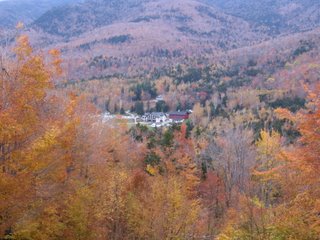
9. Wandering Highway 2 through the White Mountains of New Hampshire and Maine. We liked this narrow track so much that we drove most of it twice, once coming from Alaska to Maine and once on our tree peeping tour. Here is my description from our first drive down Highway 2:
A few minutes later we turned east on highway 2, a two lane highway that in most places Elmo could jump without a running start and which went north, west, south, up, down, and around almost as much as it went east. Villages resembling pictures of New England hamlets with names like Concord, Lancaster, Mt. Madison, Gohrman and Giliead were scattered along Highway 2 close enough to each other for the mayors to waive.
Each village had several white clapboard churches with Paul Revere steeples, stacked stone walls, salt box houses, flashes of color on the maples, roadside stands selling hand crafted maple syrup, gift shops, gardens overflowing with blooming flowers, a speed limit of twenty miles an hour and more cars from Boston than New Hampshire or Maine.
On top of that description add cool sweet air and layers of fall colors in multiple shades and values; yellow, red, orange, green, lime green, purple, rust and brown swished and swirled and dribbled across the hills and exploded in front of the white houses lining village streets.

8. Alaska Highway from Liard Hot Springs to Fort Nelson. We drove this road both directions, which I highly recommend. This drive could be number seven and eight. For example, Summit Lake is really two lakes. When you drive north it is a shock appearing as you top summit pass, naked in its bed hugged by rocky peaks. When you are going south, it is a cool drink on a hot day sipped slowly, or like Sophia Loren tossing her beach towel between my towel and the water when no one would miss me even if I stayed all day.
In either direction you drive through the Barricade Range and the Sentinel Range; you drive over Muncho Pass and Summit Lake pass, and through four Provincial Parks (the Province is British Columbia), not counting Liard Hot Springs. The road curves along with the Liard River in the North and tumbles with Tetsa River in the South and East. We stopped for stone sheep grazing in the rocks next to the road and to let reindeer and moose cross the road.
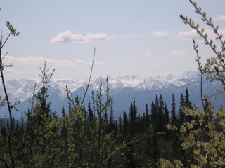
7. Alaska Highway from Haines Junction (Yukon Territory) to Tok Alaska. The view from one spot on this drive is the wall paper for my computer. Here is the essence, what I said when we were driving this road. I cannot give you a better taste.
Mountains in front of me, mountains to the right of me, mountains to the left, and mountains behind me; mountains behind mountains behind mountains; layers of mountains upon layers of mountains, and those most far, white towers where the sun streaks through the cloud, hurting my eyes. The sense of distance and mass is like other worlds, like planets or moons suddenly on the horizon, in our atmosphere.
There is so much beauty. I am not numb to it, but I am incapable of taking it all into my soul and storing that certain view of a lifetime when a turn of the head, a blink, a curve in the road presents me with another.
When we were looking at this, Annie said, “Can you imagine what David and Joey thought when they first saw this, knowing that this beauty would be their home?”
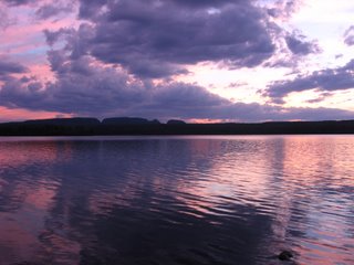
6. Drive along the northern shore of Lake Superior from Sleeping Giant to Marathon and the eastern shore from Wawa to Batchwanna Bay; Canadian Highway 17, Ontario. I left out the piece of highway that runs inland for about fifty miles. It is also beautiful, but does not compliment this visual feast. This drive was like finding an ocean in the middle of the continent. We drove for parts of three days along the shore of Lake Superior, all that in Canada. The shoreline in the US is longer than that in Canada. We camped next to the water at Sleeping Giant and Agawa Bay. This is the drive of sunsets, sunsets behind rolling mountains, sunsets slipping silently into sun colored water; this is the drive of islands, granite cliffs, small deep blue lakes sleeping in granite holes next to the great lake; the drive of roads curving around hills and dipping into valleys, bays and sandy beaches, boat filled harbors; and the drive of horizons laid with a gentle curve over the water. Famous artists come here to paint.
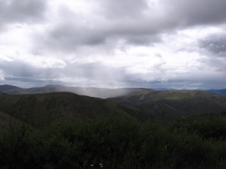
5. Top of the World Highway. This “highway” runs from the Canadian border to Dawson in the Yukon Territory. It is approximately 150 miles south of the Artic Circle. Part of the fun of this drive is that you have to go through Chicken, Alaska (named by prospectors who couldn’t spell ptarmigan) to get to the Top of the World Highway. We had driven through wilderness for much of our entire adventure. But the drive up to the Top of the World Highway and then along that highway presented a new definition of wilderness. Other than the road under our tires, Chicken, the border outpost, and a mining barge crumbling in the bottom of a canyon where more water must have one day flowed; there was no hint of human habitation; no building, no fence, no telephone or electric line, no roadside park, no plowed field, and no sign advertising that which we could not live without. The Top of the World Highway curves gracefully from ridgeline to ridgeline through high tundra. I think we could see mountains on the Artic Circle to the north. We saw the highway ten miles ahead topping a ridge, disappearing, and then reappearing as a smoky line on another ridge far to the East where the sun squeezed through dark clouds and flashed on the windshield of car we never saw. At one end of this road is the border station perched at the top of bare hill, alone, waiting for a passport to peruse, a citizen to quiz; at the other end is the free ferry that takes cars and people across the Yukon River to Dawson.
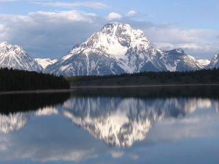
4. Drive into Grand Teton National Park, Wyoming. There had to be some of Highway 287 on this list. This drive should start on the great prairie just before 287 tumbles into the Wind River Valley near Dubois. Here is a piece of my original essay:
At one point 287 led us across a prairie that was like a yellow table cloth stretched from horizon to horizon. It seemed to have no end. And at that moment we fell off the table cloth and into the side canyons zigzagging and tumbling into the incomparable Wind River valley filled with green fields and surrounded with rocks like castles and turrets and minarets and steeples painted in alternating layers with ice cream colors, strawberry, vanilla, strawberry, vanilla, strawberry.
At the end of The Wind River valley 287 went up the mountains through the snowy pass and showed us the Teton Mountains, hazy white peaks thrust jaggedly into the heavens.
We drove, mesmerized, toward those most mountain-like of mountains until in the park where we stopped at water’s edge on a day when the air did not move and there found an inverted Mt. Moran napping on the polished surface of Jackson Lake.
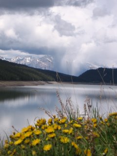
3. Banff National Park to Jasper National Park, Alberta. This drive has to be about Banff National Park and Jasper National Park because the entire drive is in one park or the other. It is the singing ice, orange lichen, and bike trail along the bow river at Lake Louise; it is the village of Jasper, Athabaska Falls, and hiking the narrow trail through the smooth tunnels and slots carved in stone by the Maligne River. It is also the high road passing gray granite mountains shimmering in early sun, passing the icefields, remnants of the last advance of the glaciers, passing black bears, buffalo, elk, big horn sheep, and finding fairy slippers next to the tent. It is smelling the earth after the rain and hearing water crash into rocks and tasting the local beer in Jasper.

2. Palmer to Matanuska Glacier, Alaska Highway 1. It was a dark and rainy evening, and a black BMW motorcycle accelerated out of Palmer whining through wisps of fog slithering over the road like fat snakes. A form clad in leather the color of fresh blood and wearing a moon walker’s helmet squeezed the BMW with her thighs and snuggled to the gas tank. The form seemed to be painted onto the motorcycle. They leaned into the sharp curves, left toward the cliff that melted and dribbled fiery gold fingers onto the road; then right toward the boiling river, the Matanuska, like curdled milk whipped with chocolate, tumbling over walking rocks and spinning milky fairies into the dripping air. They miss, but barely, the mechanical elephants hauling silver rockets toward Palmer. Rock castles flash on and off in the distant silhouetted against a rolling black sky. Behind the BMW Harry Potter and some of his friends follow on broomsticks slinging lightning bolts at the Four Horsemen of the Apocalypse. The BMW zips down a steep hill, compresses onto a high bridge, dodges ogres, and flashes up the other side of the canyon. At the top of the canyon the Matanuska Glacier appears, rises slowly out of its ancient bed and grows, swelling into the hevans and across the earth like a living organism. The BMW screams to a stop at the Scenic Overlook. An old man, a woman and a dog who had been watching the glacier glance at the motorcycle.
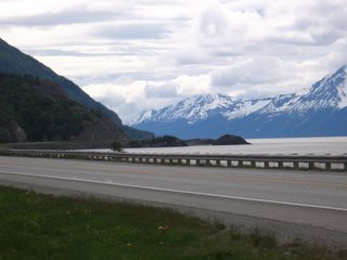
1. The Seward Highway from Anchorage to Seward, Alaska; Highway 1 and Highway 9.
We have driven this Highway more than any other in Alaska, and still it is our favorite—kind of like being married to Annie.
The Seward highway follows Highway 1 out of Anchorage to Tern Lake Junction where Highway 9 begins. Highway 9 ends at Seward, a village hanging to the edge of the mountains at the top end of Resurrection Bay. Across the bay are stark mountain peaks cut by blue green glaciers. On a clear day you can see the outline of Fox Island where Rockwell Kent hid from life with his son, painting, writing, and healing. On Top of the mountains above the village is the Harding Ice field which covers the Kenai Mountains from Seward almost all the way to Halibut Cove and is the mother to over thirty active glaciers; one of which, Exit Glacier, can be reached by car just off the Seward highway.
Boat people land in their thirty story ships in Seward and take the train or bus to Anchorage. If they fly home from Anchorage and don’t come back to Seward, they miss the best part of our number one drive. The Seward Highway is most spectacular on the drive from Anchorage to Seward. Going the other way, it would probably be only Number four.
Just as you leave Anchorage the Seward Highway tops a ridge above Potter Marsh, a great place to stop and watch sea birds. At that point you can see the first fifty miles of the Seward Highway. This section snakes along the shoreline of Turnagain Arm, a piece of ocean flowing off Cook Inlet, which is a piece of ocean flowing off the Gulf of Alaska, which is a piece of ocean responsible for feeding most species of the Pacific including humans. Turnagain Arm is shallow; Tide sweeps in and out boiling along the rocky coast and over the muddy flats like a mountain river rushing to the sea. Across the arm is the northern end of the Kenai Peninsula lined with black snow capped mountains piercing low hanging clouds or, if you are very lucky, jutting into a brilliant blue sky. Above the highway on the north side of Turnagain Arm is the Chugach Mountains laced with waterfalls, and at the far west end of the arm are the mountains giving birth to Portage Glacier which scrubbed out the rut into and out of which Turnagain Arm rushes.
From Potter Marsh; past Indian, Bird, the turn off to Girdwood and the Alyeska Ski Area (also the route to the Crow Pass Trail, which many of you know as the Girl Scout Trail); to the turn off for Portage Glacier and Whittier, Turnagain Arm and the surrounding mountains continue to thrill. For the remainder of the Seward Highway, one must be content with great mountains, high passes, lakes, thick forests, rushing streams, milky glacial rivers, canyons, trail heads leading to fabulous hikes, glaciers, and Moose Pass (the village).
There they are, Elmo’s Top 10 drives for this trip. Some of these would make a lifetime top 10 list. Where one wanders, wander slowly.



0 Comments:
Post a Comment
<< Home