Travels with Annie and Elmo

Travel should be a journey where the destination is just another part of the Journey.

Friday, September 15, 2006

Bathtub Cove


September 13, 2006

Bathtub Cove

Several days ago the moon was full. I couldn’t see it, but I knew it was there. I could see it sparkling on the edges of fog specks that jostled each other for space, glistened my glasses, amplified the owl calling from somewhere across the water and hid both the moon and the end of the dock. The dock runs from the deck behind our cottage (“cottage” is what they call a cabin on the coast of Maine) about forty feet out into the cove.

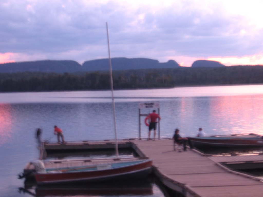
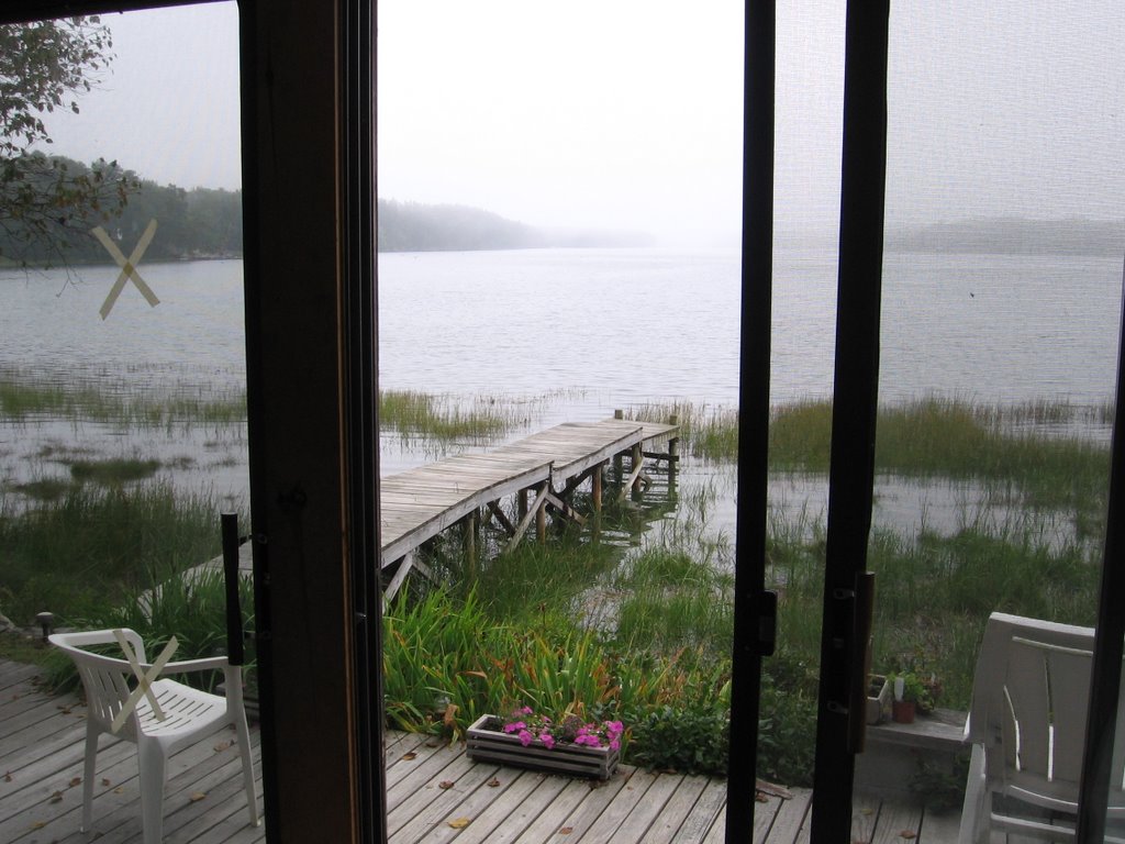
The name of the cove is Basin Cove, but I have renamed it Bathtub Cove. Bathtub Cove is about a mile and a half long, a half mile wide, and is what is called a tidal cove. That means that it fills with water at high tide and partially empties at low tide. Our Cottage is located at the head of the cove, exactly where your head would be if lying in the tub for a soak. At the other end is the drain. The drain is called Basin Cove Falls and is listed as one of the “unique natural areas” in the DeLorme Maine Atlas and Gazetteer. All water rushing in or out of the cove must squeeze through a narrow passage over granite rocks. The result is reversing rapids, southeast when the tide is going out and northwest when it is coming in. People come with their kayaks and canoes to play in the rapids.

The back of our cottage is all glass. When we wake we are looking down the length of the cove toward the falls. If the tide is high, we see water over the top of the sea grass. If it is low tide, we see mud for at least a half mile and then water. I wasn’t sure I was going to like the mud part of the cycle. I guess I was thinking of high tide and low tide like the bathroom light. You flick the switch and there is light; you flick it again and it is dark. That is not the way it is. The tide is always moving. It is like breathing, in and out, in and out, and the only time it holds it breath is when the tide changes, slack tide, and then only for a moment.

Nature is never static; it changes, always moving on to something new and exciting. We are back to rhythm, like at Hinchenbrook Island. I feel that life is rhythm, and since life is nature, the rhythm must be the rhythm of nature. We spend most of our lives fighting that rhythm and wonder why that is uncomfortable.

I like the mud because the wadding birds and shore birds come to feed; great blue heron, snowy egrets or little egrets or both (I need my friend, Georgette), lesser and greater yellowlegs, plovers, and sandpipers. The gulls come, but they also come at high tide. Our gulls are working gulls, not garbage dump gulls. They fish for a living. The cormorants come at high tide and dive under water next to the grass. Ducks float by. A pair of kingfishers swishes over the surface of the water. One day an osprey circled, hovered, and dove into the water. They all sing to us, and when the wind blows, the leaves on the paper birch and cottonwoods next to the house sing with the birds.

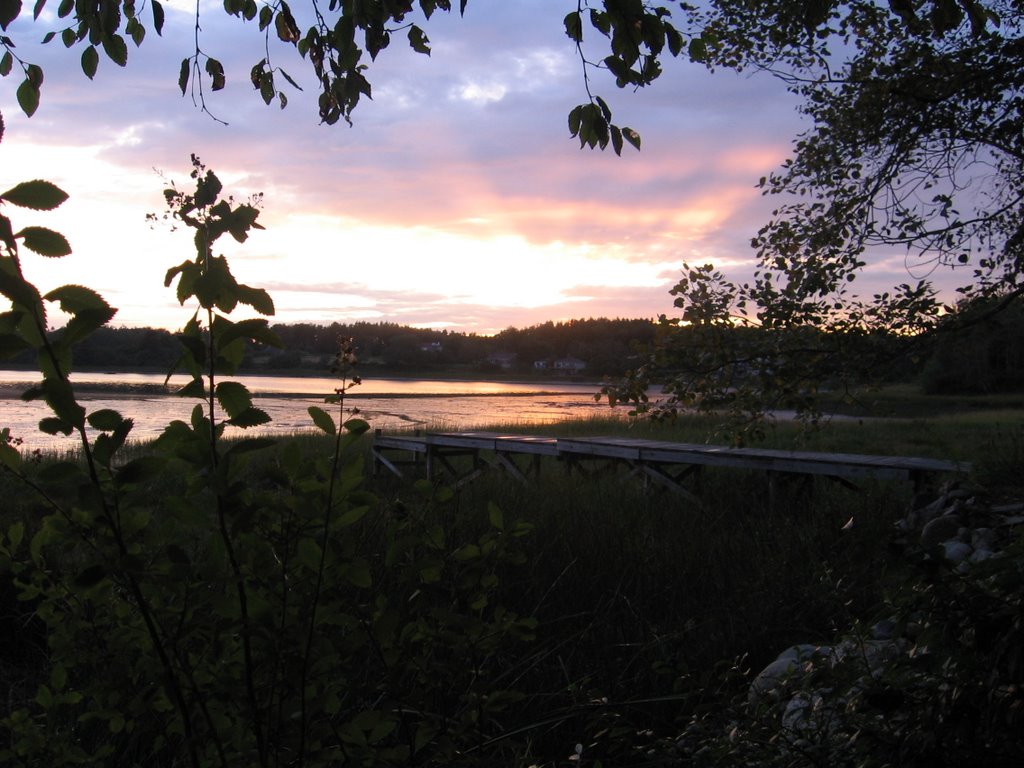
On the night of the full moon, I walked to the end of the dock. I knew it was supposed to be a really high tide, and I wanted to see how far the water came up the pilings. Somewhere between here and Calais, the moon sat on the Atlantic and pushed salty water into the Gulf of Maine. The gulf of Maine couldn’t hold it all and the water poured past Drunkers Ledge, Halfway Reef, Eagle Island and Horse Island into Cosco Bay. The moon was heavy and the water flowed by Potts point out of Cosco Bay and over Basin Cove Falls, up the cove into the salt marsh in front of our cottage and up the rocks next to the deck. The water was almost up to the board to which the planks were nailed. Only the very top of the sea grass was above the surface of the water. The grass gurgled and something slapped the water like big flat rocks dropped from a cliff. I called Annie. We listened to the gurgling and the slapping and tried to see where the fog ended and the water started.

Thursday, September 07, 2006

Lower 48

Thomas Bay behind Jonathan and Rebecca's house


Lower 48

September 1, 2006

We are back in the lower 48; first time since May. A border patrol officer; who wore a name plate that read, “Castro,” and who smiled a lot, welcomed us. We landed in Vermont where Canada’s highway 55 changes to US highway 91.

A few minutes later we turned east on highway 2, a two lane highway that in most places Elmo could jump without a running start and which went north, west, south, up, down, and around almost as much as it went east. Villages resembling pictures of New England hamlets with names like Concord, Lancaster, Mt. Madison, Gohrman and Giliead were scattered along Highway 2 close enough to each other for the mayors to waive.

Each village had several white clapboard churches with Paul Revere steeples, stacked stone walls, cracker box houses, flashes of color on the maples, roadside stands selling hand crafted maple syrup, gift shops, gardens overflowing with blooming flowers, a speed limit of twenty miles an hour and more cars from Boston than Vermont.

Highway 2 continued through New Hampshire and into Maine with little change other than more mountains. Highway 2 will call us back some day when much missed grandchildren do not wait in Brunswick.

5,151 miles from The Banks house above Turnagain Arm in Anchorage, Alaska we arrived at the Banks house above Thomas Bay in Brunswick, Maine; one great ocean to another. It was good to be home and hug grandchildren again.

Magog, the French, and Georgeville


Magog, the French and Georgeville

August 31, 2006

The government of Quebec decided to use only French on their traffic signs. For some reason in Montréal, they also decided that it would be fun to have all traffic merge and continue to merge until all French speaking Canadians and people with Texas accents were all in one lane. It took us a week to get through Montreal.

We selected a campground near Magog for our last night on the road before Maine. Unfortunately the government of Quebec decided to exclude Elmo (and all other dogs) from all Quebec provincial campgrounds. Elmo was not pleased. We considered, but not for long, a private campground. Instead Annie and the lady in the information center in Magog selected Maison McGowan sur le lac, which boasts “Cet ete laissez-nous devenir votre passeport vers la douceur de vivre,” which loosely translated means, the living is easy in Georgeville, and that Elmo is welcome.

Magog is a beautiful town on the shore of Lac Memphremagog, and Georgeville is a tiny village about 12 kilometers down the shore of the lake. This is obviously a popular tourist area, and for good reason. Our hostess at Maison McGowan said that Georgeville was originally the major town in the area. In the 1800’s the primary route from the US led through Georgeville and Magog was just a couple of houses. Now Magog is a bustling tourist center filled with restaurants, auberges, and shops; Georgeville has country homes overlooking the lake down narrow tree lined lanes, white clapboard churches with pointy steeples, a general store, and a small boat harbor in front of Maison Mcgowan.

Annie said, “The town reminded me of the town of Milford in the book series. The Anglican Church was there and all the beautiful small cottages.”

Great place for our last night on the road before Maine.

Agawa Bay to North Bay


Agawa Bay to North Bay

August 30, 2006

Our literature tells us that many famous artists have lived for a time on the eastern shore of Lake Superior. It is easy to see why, and the trees are only beginning to show color. I think we will lump the north shore and the east shore together and add it as one drive for our top 10 drives list. The drive would be along Highway 17 from Sleeping Giant Provincial Park to Batchawana Bay just outside Sault (Sue) Ste. Marie. I have only one complaint about this stretch of highway; it is a narrow two lane highway without safe places to stop and take pictures, and many pictures need to be taken.

The forest changes from the northwest end of the lake to the southeast end. On the northwest end the forest is spruce, birch, aspen; much like we had been driving through since Alaska. As we drove down the shore, eastern white pines became more prevalent, usually alone and towering over the surrounding forest. The eastern white pine may become one of my favorite trees. It is majestic. Along the lake the wind has combed its branches and needles toward the mountains, like a 100 foot tall bonsai. My tree book says that before extensive logging, they grew to 250 feet. Great old trees fill my soul with joy. Some old growth should remain for the uplifting of the soul.

Along the eastern shore the hard woods appear, mostly maples. By Batchawana Bay it is a hardwood forest. The other trees are there but the hardwoods dominate. A hint of color brushes the hill sides. Occasionally, like the girl who wears Capri pants before anyone else in school, a bold branch or tree blazes red, orange or yellow, confident that soon all the others will follow.

Sault Ste Marie is where Lake Superior and Lake Huron meet, and something happened to the land here. The granite is on the surface with shallow pockets of soil covered in brush and white stalks of dead birch trees like sun bleached thigh bones protruding from an ancient field of battle. I wonder what happened; not enough soil to grow a forest or did we did we strip the land of trees and they have not returned. Sault Ste Marie is surrounded by smoke stacks so tall that small planes and migrating geese must dodge. Not far past Sault Ste Marie we were in forest again.

Our motel night was in North Bay and unremarkable.

Sleeping Giant to Agawa


Sleeping Giant to Agawa Bay

August 29, 2006

I put on shorts and a t-shirt when I got up this morning; first time since I left Denton. I should not have ventured out. A cold front came through last night. The tops of the birch, the white spruce, and the big white pines swooshed all night long. I shivered when I got out of the tent and the doe with her fawn in the scrub spruce next to our camp site hissed at me. Elmo barked.

We drove back to 17 and continued our passage along the north and east shores of Lake Superior. The drive from Sleeping Giant to Marathon along the northern coast of Lake Superior (look for Highway 17 and Thunder Bay) may make our top ten beautiful drives. The mountains here are more abrupt, forcing the road up and down and around lakes, hills and bluffs. Something shook the granite or pushed it and pieces of mountains broke off and formed jutting islands in little lakes, cliffs, bluffs and sharp edges. Around corners Lake Superior, splotched with dark islands, makes occasional appearances reminding us of the horizon, and awing like an old movie star seen on the town square.

We bought wine and Cheetos, two of the five food groups, in Wawa (that is an actual city in Ontario) and camped next to the water on Agawa Bay. The sun is sitting and Annie is cooking steak au poivre, with balsamic reduction sauce. Elmo is trying to out stare a small gray squirrel.

Blue Lake to Sleeping Giant


Blue Lake to Sleeping Giant

August 28, 2006

The granite hills and blue lakes continue. Fairies build fairy houses on rocks next to the road. The land is smooth and rounded like grandma Hestand and easy to relax into. The only sharp edges are next to the roads where the machines cut pink rock. Ancient ice ground, polished and gouged the granite, scribbling its violent history on the surface of the rocks. A few pines, eastern white pines, raised their wind sculpted heads above the spruce, birch and aspen.

We left 17 and drove through Thunder Bay; first place since Fort Dawson we had been before. Our Thunder Bay visit was with 15 kids from Denton after a canoe trip in the Boundary Waters; over 20 years ago. Thunder Bay in 2006 was not impressive. They forgot to tell us they had moved the information center and most of former residents of downtown to the cross town expressway. And the gift shop at Old Fort William no longer carries throwing hatchets. Oh well, the memories are great.

Sleeping Giant Provincial Park occupies an Italy shaped peninsula thrust into Lake Superior. Marie Louise Campground was located on the lake of the same name. The lake was in the center of the peninsula and the mountains which give the park its name were across the lake from the campground, and behind those mountains the sun set. A doe and two fawns, still with spots, lingered in the spruce thicket next to our camp and stared at Elmo and me. We stared back.

Our drive along Lake Superior seems to be a tour of sunsets.